T42
A Public Transit Navigation System![]()
Input Start and End
Input any location worldwide: addresses, stations or points of interest
Next to textual input facilities T42 features geographic maps which can be tapped on to set your destination to that point. By default your current spatial position serves as the start. Currently in development are picking a contacts address from your contact list, selecting stations from your transit providers station network maps.
Sort
Customize your route
Choose your preferred route from the list of alternatives according to parameters you specify, such as total time, walking time and the number of transfers
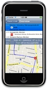
Overview
Know your route
T42 presents you an extensive overview on your route - where, when and to where you must transfer, how you get to your starting station and how you reach your destination from the last station walking - on a map and as text.
Interact
Real time navigation
T42 will lead you along your chosen route tracking your trail on the map and providing real time direction instructions. Let T42 take you by your hand and never get lost again.
Error handling
Offer alternatives if a location was not found
In case a certain location cannot be found, T42 tries to fetch alternatives that might suit your query and subdivides them into addresses, stations and points of interest.